 日本語 (Japan)
Administrative districts
In order to decipher the information in Sadajiro's book 朝鮮鉱床論 (Chōsen Kōshōron, Ore deposits of Chosen (Korea)) and its references, here we will write about the administrative districts. The reading of each kanji is shown in parentheses below based on the furigana in each edition of the Administrative District Handbooks, etc. which will be described later.
1. Chosen (Korea) thirteen Dō and subdivisions
道 - 府/郡/島 - 区/邑/面 - 町/洞/里
"Dō" (道) is the highest division in Korean Peninsula. During the Korean Empire, the country was divided into 13 Dō, and the number continued even after Meiji 43 (1910) , when it came under Japanese rule.
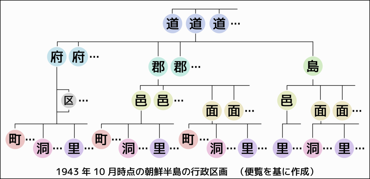
Each Dō was divided into Fu (府), Gun (郡), or Tou (島) (島 is from Taisho 4 (1915) onwards). Below them there were Yū (邑) or Men (面), and within some 府 there were Ku (区) (邑 was Showa 6 (1931) onwards). Furthermore, below them were Chō (町), Dō (洞), or Ri (里). To check these, each edition of the Administrative District Handbooks, etc. will be helpful. There are links following the table below.
Even within the same hierarchy, 府 was higher than 郡 and 島, and 邑 was higher than 面. Regarding this disparity, there are explanations in the section 府行政の状況 (Present situation of Fu administration) in 朝鮮地方行政概要 (Overview) below, and there are related legal texts in the section 邑面行政の状況 (Present situation of Yū and Men Administration) in 朝鮮地方行政例規 (Regulations) below.
2. Administrative Districts and their changes over time
I, TK compiled this table from multiple sources (note: there are errors in the sources. See below), and show how the number of administrative divisions changed from Taisho 2 (1913) to Showa 18 (1943) . Reproduction or secondary use of this table without verification is not recommended. I omitted 区 under 府.
| 資 料 | 区 画 | 咸 鏡 北 道 | 咸 鏡 南 道 | 江 原 道 | 平 安 北 道 | 平 安 南 道 | 黄 海 道 | 慶 尚 南 道 | 慶 尚 北 道 | 全 羅 南 道 | 全 羅 北 道 | 忠 清 南 道 | 忠 清 北 道 | 京 畿 道 | 計 |
|---|---|---|---|---|---|---|---|---|---|---|---|---|---|---|---|
| T2 | 府 | 1 | 1 | 1 | 2 | 2 | 1 | 1 | 1 | 2 | 12 | ||||
| 郡 | 10 | 13 | 25 | 20 | 17 | 19 | 27 | 40 | 28 | 27 | 37 | 18 | 36 | 317 | |
| T7 | 府 | 1 | 1 | 2 | 2 | 1 | 1 | 1 | 2 | 11 | |||||
| 郡 | 11 | 16 | 21 | 19 | 14 | 17 | 19 | 23 | 22 | 14 | 14 | 10 | 20 | 220 | |
| S4 | 府 | 1 | 1 | 1 | 2 | 2 | 1 | 1 | 1 | 2 | 12 | ||||
| 郡 | 11 | 16 | 21 | 19 | 14 | 17 | 19 | 22 | 21 | 14 | 14 | 10 | 20 | 218 | |
| 島 | 1 | 1 | 2 | ||||||||||||
| 面 | 81 | 141 | 177 | 193 | 147 | 221 | 252 | 272 | 268 | 188 | 175 | 110 | 249 | 2474 | |
| * | 710 | 2940 | 1971 | 1481 | 1938 | 2068 | 2584 | 3228 | 3088 | 1778 | 2250 | 1517 | 2730 | 28283 | |
| S14 | 府 | 2 | 2 | 1 | 2 | 1 | 2 | 1 | 2 | 2 | 1 | 3 | 19 | ||
| 郡 | 11 | 16 | 21 | 19 | 14 | 17 | 19 | 22 | 21 | 14 | 14 | 10 | 20 | 218 | |
| 島 | 1 | 1 | 2 | ||||||||||||
| 邑 | 5 | 4 | 7 | 4 | 1 | 8 | 14 | 8 | 8 | 4 | 6 | 2 | 4 | 75 | |
| 面 | 72 | 127 | 168 | 174 | 141 | 204 | 229 | 246 | 244 | 172 | 169 | 104 | 235 | 2285 | |
| S15 | 府 | 3 | 1 | 2 | 2 | 1 | 3 | 1 | 2 | 1 | 2 | 2 | 20 | ||
| 郡 | 11 | 16 | 21 | 19 | 14 | 17 | 19 | 22 | 21 | 14 | 14 | 10 | 20 | 218 | |
| 島 | 1 | 1 | 2 | ||||||||||||
| 邑 | 4 | 5 | 7 | 5 | 2 | 9 | 13 | 8 | 8 | 4 | 6 | 2 | 4 | 77 | |
| 面 | 72 | 125 | 167 | 173 | 138 | 203 | 230 | 245 | 244 | 172 | 168 | 104 | 230 | 2271 | |
| S16 | 府 | 2 | 2 | 1 | 2 | 1 | 3 | 1 | 2 | 2 | 1 | 3 | 20 | ||
| 郡 | 11 | 16 | 21 | 19 | 14 | 17 | 19 | 22 | 21 | 14 | 14 | 10 | 20 | 218 | |
| 島 | 1 | 1 | 2 | ||||||||||||
| 邑 | 7 | 7 | 8 | 7 | 2 | 9 | 12 | 10 | 10 | 6 | 7 | 4 | 4 | 93 | |
| 面 | 69 | 123 | 167 | 164 | 138 | 203 | 230 | 241 | 242 | 169 | 165 | 102 | 228 | 2241 | |
| S18 | 府 | 3 | 2 | 1 | 2 | 1 | 3 | 1 | 2 | 2 | 1 | 3 | 21 | ||
| 郡 | 11 | 16 | 21 | 19 | 14 | 17 | 19 | 22 | 21 | 14 | 14 | 10 | 20 | 218 | |
| 島 | 1 | 1 | 2 | ||||||||||||
| 邑 | 7 | 11 | 13 | 9 | 5 | 11 | 13 | 11 | 13 | 7 | 11 | 4 | 8 | 123 | |
| 面 | 68 | 119 | 161 | 161 | 134 | 199 | 226 | 240 | 239 | 168 | 161 | 102 | 223 | 2201 | |
| * | 794 | 2966 | 1988 | 1488 | 1937 | 2075 | 2619 | 3264 | 3102 | 1827 | 2282 | 1503 | 2764 | 28609 |
- T2 = 「改正新旧対照市町村一覧, 鍾美堂, Taisho 2 (1913) 」, 国立国会図書館デジタルコレクション
- T7 = 「最近検定市町村名鑑, 藤沢衛彦, 地方名鑑発行所, Taisho 7 (1918) 」, 国立国会図書館デジタルコレクション
- S4 = 「地方行政区域名称一覧 Showa 4 (1929) 4 月改訂, 朝鮮総督府内務局」(表はShowa 4 (1929) 9 月 5 日現在) , 国立国会図書館デジタルコレクション
- S14 = 「外地地方行政区画便覧 Showa 14 (1939) 3 月10日現在, 拓務省管理局」, 国立国会図書館デジタルコレクション
- S15 = 「外地地方行政区画便覧 Showa 15 (1940) 4 月 1 日現在, 拓務省管理局」, 国立国会図書館デジタルコレクション
- S16 = 「外地地方行政区画便覧 Showa 16 (1941) 4 月 1 日現在, 拓務省管理局」, 国立国会図書館デジタルコレクション
- S18 = 「朝鮮行政区画便覧 Showa 18 (1943) 10 月 1 日現在, 朝鮮総督官房地方課, 1943」, 国立国会図書館デジタルコレクション
- * = 「町」+「洞」+「里」
Materials (Administrative District Handbook, etc.)
(Some of the links above overlap with ones in the Search function description on the "Related Maps" page.)
About errors in the materials
When further verifying the above table, please be aware that there are at least two errors in the materials. One is the column for 島 in 全羅北道 in the relevant information on p.11 of the Showa 14 (1939) version. It looks like the number "one", but it is a typographical error. The vertical bar type character representing 0 has been mistakenly rotated 90 degrees. The horizontal number "2" is correct. Another error is that on page 509 of the 名鑑 (T7 in Taisho 7 (1918) ), the 群山府 on the same page has been forgotten to count and described as only "全羅北道(十四郡)" though 全羅北道 should have one 府 and forteen 郡 (There is no table like the Showa version, so we need to read what is in parentheses at the beginning of each 道).
3. Example of research process using administrative district materials

There are misspelling and typographical errors (wrong selection and/or rotation of typefaces) here and there in Sadajiro's 朝鮮鉱床論 (Ore deposits of Chosen (Korea)) (hereinafter referred to as his original). It can be determined by comparing it with multiple materials.
For example, in his original "Part 2 Metal Deposits" - "Chapter 1 Gold and Silver Deposits" - "43. 天王金山" (Ten'nō Gold Mine), it says "平安南道 价川郡 中西面。他二面に跨る...". (The mine is at Nakanishi(?)-men, Kaisen-gun, Heian'nandō. Also it is spanning two otehr Mens...). However, from the references in that chapter, the administrative district handbooks, Mining claims (List of mines), Topographic maps, etc., it is clear that this "two other Mens" is incorrect, and "平安南道价川郡中西面、外西面の計二面" (The mine is at Nakanishi(?)-men and Sotonishi-men of Kaisen-gun, Heian'nandō) is correct. In other words, the mine is spanning only 中西面 and 外西面. We can imagine that the cause of the error is that during the preparing to print, 外 was read as hoka and the typeface of 他 with the same reading was picked up.
However, since administrative districts change, it is insufficient to make a judgment based on only a small amount of information. It is necessary to check along the time axis to see whether the name 外西面 was changed to 外二面/他二面 or not.
For example, in the official gazette of Showa 2 (1927), 外西面 appears, but in the list of local administrative area names (linked above) in Showa 4 (1929), there is no 外西面 in 价川郡, so 外西面 may have disappeared at least once. However, it is not possible to determine whether or not the typesetting was done knowing that 外西面 did not exist. In any case, it seems that Sadajiro's original is incorrect regarding the "他二面" based on various versions of several materials. (As no handwritten manuscript remains, it is unknown whether this was a mistake in the manuscript or a typographical error.)