 日本語 (Japan)
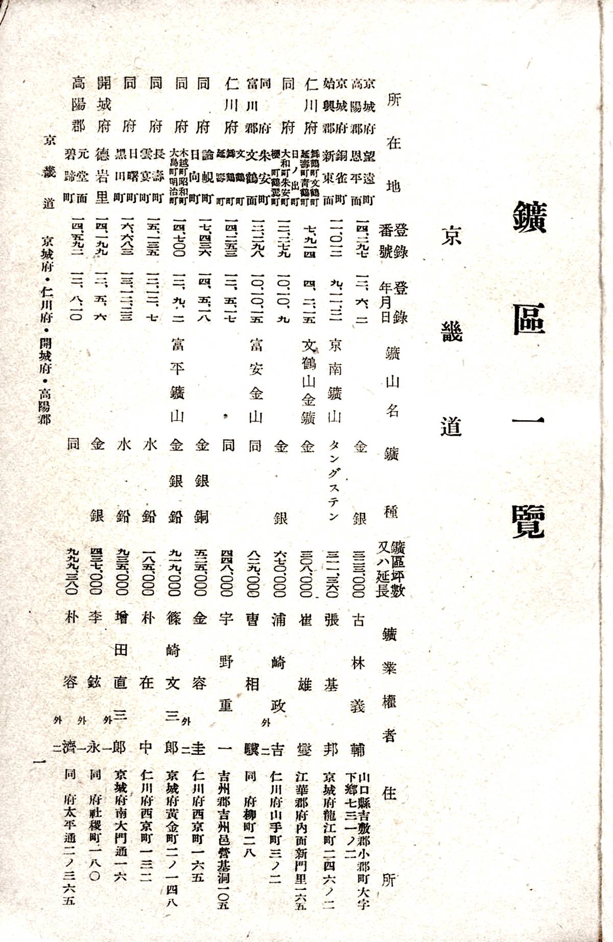
鉱区一覧 (List of Mining Areas) is a summary of the mineral type, location, area, permit date, etc. of registered mining areas, and those related to Korea were published annually from the end of the Meiji era to the Showa era. We can check not only changes in management information of mining area (changes in registrants, registered names and addresses, consolidation, abolition, new establishments, etc.), but also changes in administrative district (consolidation, abolition, new establishments, etc.).
Changes in management information may also be found in the Official Gazette.
Publicly available Korean Penisula 鉱区一覧 (List of mining areas)
この画像は、下記を基に作成しました。
朝鮮総督府殖産局鉱政課 編『朝鮮鉱区一覧 : 昭和16年7月1日現在』,朝鮮鉱業会,1942.2. 国立国会図書館デジタルコレクション https://dl.ndl.go.jp/pid/1905834 (参照 2023-09-24)
- [朝鮮]鉱区一覧 Meiji 43 (1910) 末日現在
- 鉱区一覧 Taisho 3 (1914) 1 月 1 日現在
- 鉱区一覧 Taisho 4 (1915) 1 月 1 日現在
- 鉱区一覧 Taisho 5 (1916) 1 月 1 日現在
- 鉱区一覧 Taisho 6 (1917) 1 月 1 日現在
- 鉱区一覧 Taisho 7 (1918) 1 月 1 日現在
- 鉱区一覧 Taisho 8 (1919) 1 月 1 日現在
- 鉱区一覧 Taisho 9 (1920) 1 月 1 日現在
- 鉱区一覧 Taisho 10 (1921) 1 月 1 日現在
- 鉱区一覧 Taisho 11 (1922) 1 月 1 日現在
- 鉱区一覧 Taisho 12 (1923) 1 月 1 日現在
- 鉱区一覧 Taisho 13 (1924) 1 月 1 日現在
- 鉱区一覧 Taisho 14 (1925) 1 月 1 日現在
- 鉱区一覧 Taisho 15 (1926) 1 月 1 日現在
- 朝鮮鉱区一覧 Showa 2 (1927) 1 月 1 日現在
- 朝鮮鉱区一覧 Showa 3 (1928) 1 月 1 日現在
- 朝鮮鉱区一覧 Showa 4 (1929) 1 月 1 日現在
- 朝鮮鉱区一覧 Showa 5 (1930) 1 月 1 日現在
- 朝鮮鉱区一覧 Showa 6 (1931) 1 月 1 日現在
- 朝鮮鉱区一覧 Showa 7 (1932) 1 月 1 日現在
- 朝鮮鉱区一覧 Showa 8 (1933) 1 月 1 日現在
- 朝鮮鉱区一覧 Showa 9 (1934) 1 月 1 日現在
- 朝鮮鉱区一覧 Showa 10 (1935) 1 月 1 日現在
- 朝鮮鉱区一覧 Showa 11 (1936) 1 月 1 日現在
- 朝鮮鉱区一覧 Showa 12 (1937) 7 月 1 日現在
- 朝鮮鉱区一覧 Showa 14 (1939) 7 月 1 日現在
- 朝鮮鉱区一覧 Showa 15 (1940) 7 月 1 日現在
- 朝鮮鉱区一覧 Showa 16 (1941) 7 月 1 日現在
An example research process using Mine lists
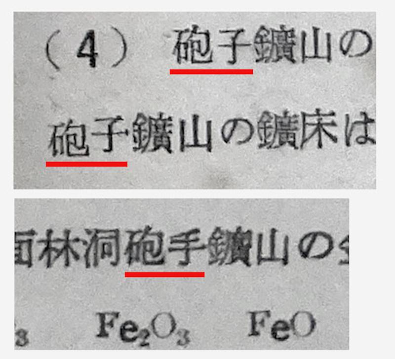
In Sadajiro's 朝鮮鉱床論 (Ore deposits of Chosen (Korea)) (hereinafter referred to as his original), there are some variations in the notation. For example, near the end of the book, 砲子鉱山 (Hōshi mine) and 砲手鉱山 (Hōshu mine) appear in "Part 4 Nonmetallic Deposits," - "Chapter 4 Mica Deposits," - "2. Deposits", but they appear to be pointing to the same single mine from what the surrounding sentences indicate. Is only one of the words 砲子 and 砲手 correct, or are both correct due to a name change or aggregation? To determine it, it is necessary to check the notation on topographic maps, mining area lists, etc. along with time axis.
(Actually, if we read “Reference No. 11” at the end of the “Chapter 4 Mica Deposits” first, we can tell that it is a “rename”, but if we take “(References 1, 4, and 14)” in his original at face value and do not read "11", we will be forced to take a slightly detour as shown below.)
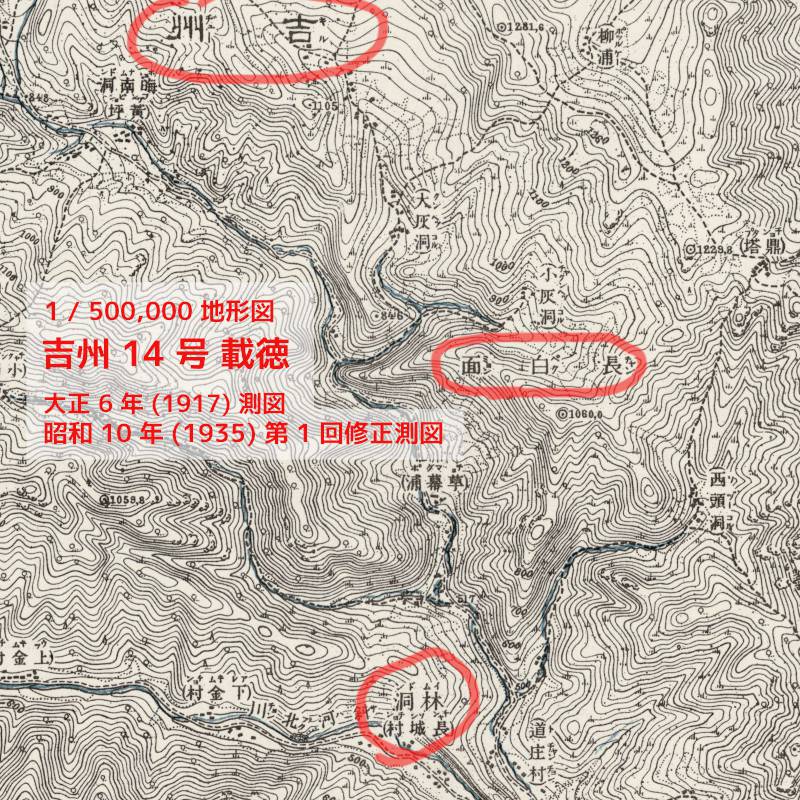
First, we assume that the original article's below is right: "咸鏡北道 吉州郡 長白面 林洞から咸鏡南道 端川郡 北斗日面 大新里に亘る" ("It is spanning from Rin-dō(?), Chōhaku-men, Kisshū-gunm, Kankyō'nandō to Daishin-ri, Hokutonichi-men(?), Tansen-gun, Kankyō'nandō.")
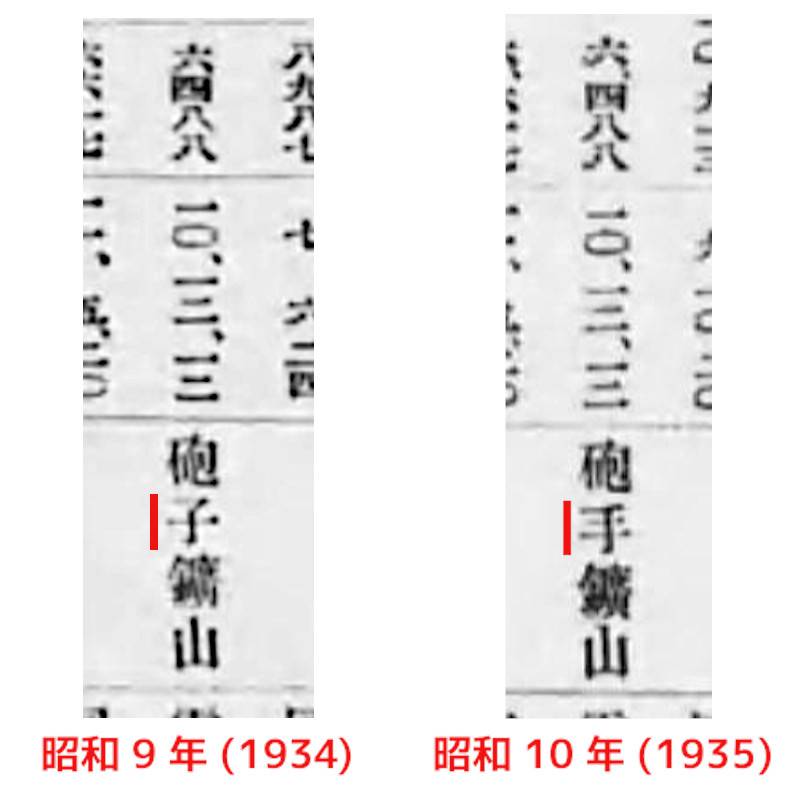
Looking at the 1 / 50,000 topographic map, you can find 林洞 (Rin-dō) in 吉州 14 号 載徳 (Kissyū No.14 Saitoku) and 大新里 (Daishin-ri) in 甲山 2 号 新福場 (Kōsan No. 2 Shimpukujō) (for detailed locations, see annotationin "Reprint version PDF"). ). On the other hand, looking at each year's edition of the "List of Mining Areas," you will find that among the mines in 咸鏡北道 where mica can be mined, the registration number 6488 corresponds to one with the word 砲子 or 砲手. It is written as 砲子 until 1934, and as 砲手 after 1935.
Furthermore, when searching the official gazette, we found a column in the May 12 Showa 9 (1934) 朝鮮総督府官報 (Official Gazette of the Government-General of Korea) titled 「礦業事業所名稱改稱届」(Notification of name change of mining business establishment name) (鉱業事業所名称改称届 in modern kanji). It can be seen that the name change notification was submitted on April 28.
Here, let's check the contents of "Reference No. 11" published by Showa 10 (1935) to see if it's correct. It includes 地質学雑誌 第 42 巻 (1935) (The Journal of the Geological Society of Japan, Vol. 42, 1935) and 岩石礦物礦床學 第 14 巻 (1935) 第 2 号 (The Journal of the Japanese Association of Mineralogists, Petrologists and Economic Geologists, Vol. 14 (1935) No. 2). We find that the latter "(1) 資料", it is written that "砲手鉱山は従来砲子鉱山と称されたるも,昭和九年四月改名せり。" (The 砲手 (Housyu) Mine was formerly known as the 砲子 (Houshi) Mine, but the name was changed in April 1930.'' This is consistent with the information in the official gazette and the list of mining areas.
In summary, Sadajiro's original omits the fact of the name change even though it should have been mentioned, resulting to make the reader wonder if there is a unreasonable discrepancy in the notation.